Javascript is required

Remote Sensing Monitoring Of Electricity

Based on the high-precision, real-time, and intelligent satellite remote sensing data acquisition capability of the `Dongfang Huiyan` constellation, as well as the key technology of high-precision intelligent processing of remote sensing data by Academician Li Deren's team and the multi-source remote sensing data production line of Wuhan University, Luhai Kongjian achieves the aggregation and processing capability of massive multi-source heterogeneous spatiotemporal data, and accumulates multi-disciplinary spatiotemporal big data application solutions, which can provide products and services to users in various fields

图片
Problems in the operation and management of ultra-high voltage transmission lines

In traditional electricity, there are four major problems

Poor environment
Poor environment

Ultra high voltage transmission lines are often located in mountainous areas and are prone to the impact of wildfires and other factors.

Varied topography
Varied topography

The location of ultra-high voltage transmission lines is in complex terrain areas, which are easily affected by geological disasters, floods, and other disasters.

Safety hazards around the line

There is a hidden danger of external damage caused by human construction around the ultra-high voltage transmission line channel.

Difficulty in monitoring

The traditional patrol method faces difficulties in monitoring due to high labor intensity, difficult working conditions, low monitoring efficiency, and inability to reach special conditions.

Solution

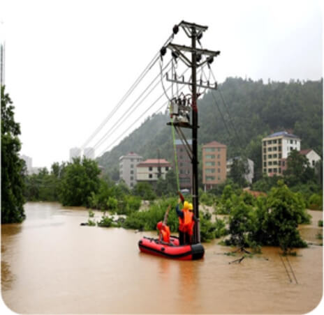
Remote sensing monitoring of electricity

brief introduction

Compared with traditional power engineering monitoring, satellite remote sensing technology has a higher monitoring frequency and a larger coverage range.

At the same time, the labor cost invested is relatively lower, and safety and other aspects are more guaranteed.

Can provide effective solutions in disaster monitoring and early warning, channel environment inspection, and monitoring of changes in surrounding conditions, with a wide range, precision, and multi temporal approach.

To address the above issues, remote sensing satellites can be used to achieve monitoring effects around ultra-high voltage transmission lines, including 1-kilometer survey, 500 meter prevention and control, and 300 meter strict control`1 kilometer survey, 500 meter prevention and control, 300 meter strict control`onitoring effects around ultra-high voltage transmission lines, including 1-kilometer survey, 500 meter prevention and control, and 300 meter strict control.

Application scenarios

The application direction of remote sensing satellites in the power industry

photo
Mountain fire monitoring
View details
photo
Geological hazard monitoring
View details
photo
External rupture monitoring
View details
photo
Flood disaster monitoring
View details
Application scenarios

Automatic monitoring of wildfires in the power grid

brief introduction

Satellite types include NPP, FY-4, FY-3, Kuihua-8, NOAA-15, NOAA-18, NOAA19, NOAA20, etc.

Implement fire point monitoring in a 1-kilometer area around key monitoring transmission lines, with a monitoring frequency of every 10 minutes and a receiving and processing time of 20-25 minutes;

Provide weekly fire risk level prediction services during key fire prevention periods;

Provide monthly fire monitoring and statistical reporting services;

Timely conduct damage assessment reports after each fire.

With the continuous development of power grid construction, there are more and more transmission and transformation lines passing through mountainous areas. Forest fires that occasionally occur around power transmission lines can cause line trips or shutdowns, and can pose a threat to the safety and reliability of the power system. Based on the current generation of remote sensing satellite data both domestically and internationally, combined with automated fire point identification algorithms, it is possible to provide automatic monitoring services for power grid wildfires, with the optimal implementation of monitoring every 10 minutes.

15801018805

Satellite Data Industrial Park, Fengcheng Street, Haiyang City, Yantai City, Shandong Province

微信二维码
微博二维码
陆海空间(烟台)信息技术有限公司

Luhai Kongjian(Yantai) Information Technology Limited Company

微信二维码
微博二维码

15801018805

Satellite Data Industrial Park, Fengcheng Street, Haiyang City, Yantai City, Shandong Province