Javascript is required

Ocean Remote Sensing Monitoring

The company uses satellite remote sensing technology to predict the distribution of marine fish resources as the basis for scientific and standardized management of marine fishing in the marine ecological environment. The timely acquisition of remote sensing data such as cloud maps, wind, waves, and sea ice can also improve the safety of marine fishing operations and provide meteorological support for fisheries. Remote sensing satellites are used in fishery function zoning, wetland protection, mudflat development and planning and other fields. According to the information in visible and near infrared bands in marine remote sensing, mudflat and wetland information can be retrieved and made into thematic maps, providing scientific basis for a series of marine development, planning and construction.

图片
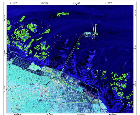
Monitoring of nearshore floating raft aquaculture, aquaculture, and fishing vessels
创建高保真UI设计更快捷
Fine extraction of aquaculture areas in aquaculture areas

According to the marine functional zoning, carry out regular investigations, monitoring, and evaluations of the resources and environment in the functional areas, and grasp the operational status of the functional areas. In accordance with the goal of ensuring the safe, healthy, and stable operation of marine functional zones, we will develop a plan for adjusting the use of key sea areas, gradually carry out comprehensive coastal and sea area improvement projects in functional damaged areas, strengthen natural shoreline protection, adjust sea area use projects that do not comply with marine functional zoning, accelerate the construction of coastal protective forests, rectify damaged coastal, bay, island, and estuarine ecosystems, strengthen the construction of marine natural disaster observation, prediction, and prevention systems, and effectively improve marine functional service capabilities.

15801018805

Satellite Data Industrial Park, Fengcheng Street, Haiyang City, Yantai City, Shandong Province

微信二维码
微博二维码
陆海空间(烟台)信息技术有限公司

Luhai Kongjian(Yantai) Information Technology Limited Company

微信二维码
微博二维码

15801018805

Satellite Data Industrial Park, Fengcheng Street, Haiyang City, Yantai City, Shandong Province